The newsletter for climate-aware risk professionals.
The climate producing today's storms is not the climate that produced the historical record. Join 400+ risk professionals receiving the latest insights from Reask direct to their inbox.

Insights
Hurricane Melissa and Jamaica: Understanding extreme event risk in a changing climate
How Hurricane Melissa exposed the limits of traditional catastrophe models — and what Reask's climate-conditioned analysis revealed about extreme event risk across Jamaica.

Jamie Rodney
|
CEO, Reask

Hurricane Melissa serves as a stark reminder of the North Atlantic and Caribbean’s vulnerability to severe tropical cyclone events. It also raises important questions about how we continue to advance our understanding of hurricane risk in an era of a changing climate.
Executive summary (long read)
Melissa exposed extreme spatial variation in Jamaica’s wind risk, with parts of the island seeing 1,000–4,000-year return-period winds.
Historical data is too limited (only four major hurricanes in the reliable record) to explain events of this magnitude.
Melissa exceeded all historical wind-speed maxima across much of Jamaica, especially in the central highlands.
Traditional models require enhancement with rare, climate-driven extremes, particularly as sea temperatures and atmospheric patterns shift.
Reask’s UTC model expands the sample space, simulating thousands of climate-conditioned seasons to capture a fuller range of plausible outcomes.
Melissa illustrates why combining traditional and climate-conditioned modelling gives a more accurate view of tail risk.
For a detailed look at how Reask's data supported decisions from forecast through to settlement, see our companion case study.
The Melissa reality check
Before examining Melissa’s local impacts, it’s important to understand how hurricane risk differs between a single location and an entire region. Figure 1 presents a return-period analysis for Kingston, Jamaica’s capital and largest urban centre.
This Cat-in-Circle analysis compares historical observations (IBTrACS data shown in black and grey for two periods: 1900–2021 and 1980–2021) within a 80 km radius of Kingston, against Reask’s UTC model ensemble simulations (blue and green lines), each representing a plausible realisation of those same historical climates.
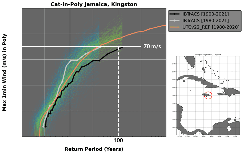
Figure 1: Maximum 1-minute wind speed return periods for Kingston, Jamaica. Historical observations (black and grey lines) represent our single observed reality, while Reask’s UTC ensemble (coloured lines) illustrates the full range of possible outcomes under identical climate conditions. The orange line indicates the UTC reference climatology for 1980–2020.
Key observations from the analysis
Several insights emerge from this analysis:
At a 100-year return period, Kingston can expect maximum winds around 70 m/s (approximately 250 km/h).
The historical record represents only one path through the broader probability space.
The UTC ensemble highlights substantial uncertainty, some realisations show much higher winds at the same return period, others lower.
Location matters: This risk profile reflects storms passing within 50 kilometres of Kingston, not Jamaica as a whole.
Zooming in to specific locations (1km grids) using Reask wind speed return period maps we see how dramatically risk can vary spatially (Figure 2).
Return period analysis shows that central Jamaica experienced wind speeds with return periods exceeding 1,000 years well inland; return periods far in the tail compared to the cat-in-a-circle analysis.
The mountainous interior, particularly around the central parishes, saw return periods stretching from 500 to 2,000 years, with some isolated coastal pockets reaching an extraordinary 3,000-4,000 year return period levels.
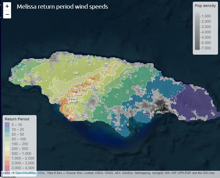
Figure 2: Return period wind speeds from Hurricane Melissa, with population density overlay. Central highlands experienced return periods of 1,000-2,000 years, while coastal areas in more densely populated areas saw 20-50 year events.
The spatial pattern and Jamaica’s vulnerability
The spatial pattern reveals something crucial about Jamaica’s vulnerability. While coastal areas in the east experienced return periods of 20–50 years (still significant, but more typical for hurricane-prone regions), the coastal landfall zones and western and central highlands bore the brunt of truly extreme winds.
These are the areas where return periods rose to 100, 250, 500 years and beyond, creating a patchwork of devastating winds that push the boundaries of what our historical experience can explain.
This contrast between Kingston’s localised risk profile (Figure 1) and the island-wide impact patterns (Figure 2) highlight a critical challenge: risk is not uniform across a region. A 100-year event for Kingston may coincide with a 1,000-year event in the central highlands just 50 kilometres away, depending on storm track and topography.
This raises an important question for the catastrophe modelling community: when dealing with events that occur once every 500, 1,000, or even 2,000 years, how can we extend beyond observational records spanning just a few decades to provide more robust risk estimates?
The historical context: Jamaica’s hurricane legacy
Jamaica’s location in the Caribbean makes it particularly vulnerable. Looking at NOAA’s historical hurricane database for the region around Jamaica, filtered for major hurricanes (Category 3 or higher), we find a remarkably sparse record (Figure 3).
The database shows just four major hurricanes that have directly threatened the island in the modern era, none of which reached Category 4 or 5 strength at landfall:
Hurricane Gilbert (1988) – A Category 5 storm that crossed directly over Jamaica, the most devastating in living memory before Melissa.
Hurricane Charlie (1951) – A Category 4 storm that passed near the island in August 1951.
Unnamed hurricanes (1903 and 1912) – Events dating back to the early 20th century, when record-keeping was far less reliable.
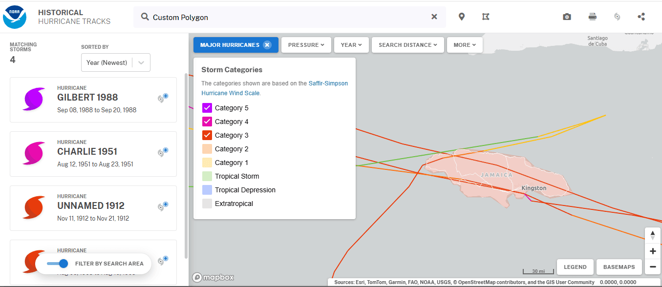
Figure 3: NOAA’s historical hurricane database showing major hurricanes (Category 3+) that have threatened Jamaica. Only four events appear in the reliable modern record.
The most instructive comparison comes from Gilbert.
Historical wind speed data, calculated using Metryc Historical, show that while Gilbert impacted the entire island, maximum wind speeds varied considerably — from 50–100 km/h in some eastern areas to 175–200 km/h across much of the island, with the most extreme winds over mountainous areas in the north (Figure 4).
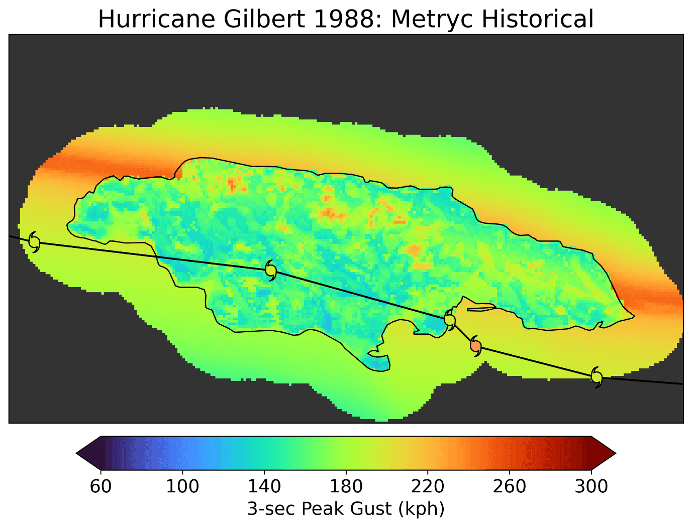
Figure 4: Hurricane Gilbert (1988) three-second peak gust analysis showing wind speeds across Jamaica.
When we compare Melissa’s footprint to the historical maximum wind speeds (as simulated by Reask’s historical wind-speed database, Metryc Historical), Melissa’s wind field in central Jamaica exceeded historical maxima across nearly half the island, and by a wide margin in the highest-wind areas.
Regions that had never experienced winds above 150 km/h were suddenly hit with gusts exceeding the historical maximum by 100 km/h or more (Figure 5).
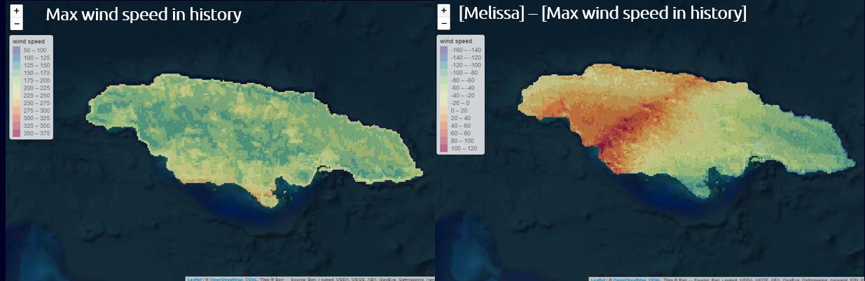
Figure 5: Left: historical maximum wind speeds across Jamaica from Metryc Historical; right: Melissa’s maximum wind speeds, revealing areas where Melissa exceeded all historical precedent.
This highlights a fundamental challenge in catastrophe risk assessment. While historical data provide the foundation for understanding hurricane risk, four major data points over several decades, even including the catastrophic Gilbert, represent a limited sample from which to extrapolate tail risk.
The statistical challenge of rare events
Hurricane landfalls are, by nature, rare events, a reality long recognised in catastrophe modelling.
For Jamaica, the historical track data make this challenge clear. Even when expanding the analysis to include all major hurricanes passing within 30 miles of Jamaica’s coast, we find only a handful of events, including Beryl (2024), with Gilbert (1988) remaining the most significant.
Major hurricane strikes on Jamaica occur roughly once every decade or two, perhaps even less frequently depending on how “direct impact” is defined. This creates a very small sample size, a challenge the insurance and reinsurance industries have addressed through increasingly sophisticated modelling techniques over recent decades.
The limitation deepens when considering that each historical storm occurred under a different background climate.
For example, Figure 6 shows that sea surface temperatures (SSTs) prior to Hurricane Gilbert’s landfall were almost a degree cooler than those before Melissa. This warming trend adds another dimension of uncertainty when evaluating historical storms.
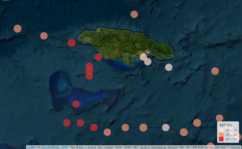
Figure 6: Track points and SST values for Hurricanes Melissa and Gilbert, showing that SSTs during Melissa (2025) were more than a degree warmer than during Gilbert (1988).
The challenge becomes even greater when we examine extreme events like Melissa. Return-period analysis shows wind speeds in central Jamaica expected only once every 1,000–2,000 years.
How do we estimate probabilities for such events when reliable observational records span only 40–50 years, and the full historical database contains just a few comparable storms, each under different climate conditions?
This is where the catastrophe modelling community continues to innovate, seeking complementary approaches to extend beyond traditional methods.
Building on traditional foundations
Traditional catastrophe models have served the industry well, providing the empirical backbone for risk assessment and pricing. Built on analyses of historical storm tracks, intensities, and impacts, they’ve enabled quantification of risk where none existed before.
However, these foundational approaches can be enhanced by incorporating additional sources of information.
NOAA’s historical hurricane tracks around Jamaica capture observed events, each with unique track and intensity profiles, but the observational record only reflects what actually happened, not the full range of what could have happened under similar or changing climate conditions.
Comparing Gilbert’s 1988 wind footprint with Melissa’s provides an important observation: storms can impact the same island in radically different ways. Gilbert tracked southwest to northeast across Jamaica, producing one pattern of devastation.
Melissa’s track, evident in the return-period patterns, created another, with the western and central regions bearing the brunt.
To strengthen risk assessments, we must incorporate:
The evolving baseline of sea surface temperatures, wind shear, and atmospheric conditions that influence storm behaviour.
The broader probability space of possible outcomes under the same or alternative equally plausible climate conditions.
Melissa is particularly instructive. Its intensity and impact reflect specific atmospheric and oceanic conditions.
Return-period data show that Jamaica’s central mountains experienced disproportionate impacts. Understanding how often these atmospheric configurations occur and how they are changing provides valuable context beyond the sparse observational record.
Extending the boundaries: Climate-conditioned modelling
Building on decades of catastrophe-modelling innovation, Reask’s Unified Tropical Cyclone (UTC) model represents an extension of traditional approaches into the realm of climate science.
Rather than replacing empirical methods, it complements them by incorporating the physical processes that govern tropical cyclone behaviour.
The core innovation lies in integrating key climate drivers such as sea surface temperature, wind shear, and steering flow into every component of the statistical model, from storm genesis to movement and intensity.
1. Physical grounding alongside empirical analysis
Traditional models excel at extrapolating observed storm behaviour. Reask’s UTC model builds on this foundation by explicitly incorporating:
Sea surface temperatures (SSTs)
Wind shear patterns
Steering flow dynamics
Regional climate variability (e.g. ENSO)
Every simulated storm is driven by actual climate conditions, making the model inherently responsive to climate change signals that may not yet be visible in limited observational data. The model validates against historical records while exploring previously uncharted regions of the probability distribution.
2. Expanding the sample space through ensemble methods
For any given year, Reask generates 2,500 simulations of what could have happened under that year's climate conditions. This ensemble approach reveals that the observed historical record, including events like Melissa and Gilbert, represents just one possible realisation from a much broader distribution of outcomes.
The model has generated over 2.5 million years of synthetic tropical cyclone events, providing a rich sample that complements the observational record. This approach does not replace traditional modelling methods, it expands the existing data into the tails of the distribution that observations and existing stochastic methods alone cannot adequately sample.
Some simulations might show even more catastrophic storms than Melissa, imagine Gilbert's intensity but with Melissa's track, or vice versa. Others might show near-misses that, in our observed reality, became devastating hits. This range of possibilities helps risk managers understand not just what did happen, but what could happen given the uncertainty in the climate state.
3. Detecting emerging trends in a non-stationary climate
When climate conditions are changing, as they demonstrably are, traditional trend detection faces challenges due to data scarcity. By simulating each year multiple times under its specific climate forcing, the UTC model can help identify shifts in risk that haven't yet manifested clearly in the limited observational record.
For Jamaica, this means understanding whether storms producing 1,000+ year return period winds in the central highlands are becoming more or less likely. The fact that Melissa exceeded historical maximum wind speeds in certain locations suggests the hazard landscape may be shifting.
But with only Gilbert, Charlie, and a handful of other events in the historical record, observations alone cannot determine whether Melissa represents:
A genuine shift in the intensity distribution
Natural variability within a stable climate regime
A harbinger of more frequent extreme events to come
Reask's ensemble approach can help disentangle these possibilities by simulating what the current climate regime looks like compared to historical baselines, providing context that extends beyond what any individual observed event can tell us.
The model is peer-reviewed and published in EGUsphere by Dr Thomas Loridan and Dr Nicolas Bruneau, demonstrating how machine learning frameworks can reflect the physical realities of a changing climate while remaining grounded in empirical validation.
The landfall percentage question: an ongoing research area
This brings us to an intriguing question in hurricane risk assessment: is the percentage of named storms that make landfall changing over time?
Traditional analysis of the Atlantic Basin suggests this percentage has remained relatively stable, around 10–12% of named storms become landfalling hurricanes. This finding provides valuable context for risk assessment.
However, there are physical reasons to suspect this relationship may be evolving:
Warmer seas could enable storms to maintain intensity longer, increasing the chance they reach land at hurricane strength.
Shifting steering patterns may be altering storm tracks and landfall locations.
The 2006–2016 hurricane drought, an unprecedented 11-year period without a major U.S. landfall, hints at variability we don’t yet fully understand.
Reask’s ensemble approach offers a complementary method to explore this question.
By simulating historical years thousands of times and comparing basin-wide activity with landfalling events, researchers can assess whether observed patterns reflect stable climatology or emerging trends masked by natural variability, trends not yet statistically visible but crucial for forward-looking risk assessment.
From Melissa to enhanced risk intelligence
So, what does Hurricane Melissa teach us about advancing hurricane risk assessment for the Caribbean and beyond?
First, extreme events demand our continuous attention. As sea surface temperatures rise and atmospheric conditions shift, events that were once millennial rarities may become more frequent. We can't treat Melissa as a pure outlier, we need to understand the conditions that produced it and how often those conditions might recur.
Second, complementary approaches strengthen our understanding. Traditional methods provide essential grounding, but we can enhance them by incorporating climate science and expanding our exploration of the probability space through physically-based simulation.
Third, uncertainty quantification is valuable. Reask's ensemble approach doesn't eliminate uncertainty, it quantifies it in a physically meaningful way. By showing the full range of possible outcomes under different climate states, risk managers can make more quantifiable decisions about exposure, capital allocation, and resilience investments.
Finally, the landfall question merits ongoing research. Understanding whether storms are becoming more likely to make landfall as hurricanes, and where, is crucial for insurers, governments, and communities. The tools to investigate this question are evolving, combining physical climate science with advanced statistical modelling and traditional empirical analysis.
Looking ahead: advancing catastrophe risk assessment
Hurricane Melissa will eventually fade from headlines, but its legacy should endure in how we continue to advance catastrophe risk assessment. The storm exposed vulnerabilities in Jamaica's infrastructure and highlighted opportunities to enhance traditional risk models with insights from climate science.
The convergence of traditional modelling, physical climate science, and advanced simulation methods offers a path forward. By grounding risk assessment in both observational evidence and physical processes, we can:
Better anticipate extreme events before they occur
Quantify risks for locations with limited historical experience
Adapt our models as the climate continues to change
Provide more robust probability distributions for tail events
Price insurance products with greater uncertainty quantification
For Jamaica and other vulnerable regions, this isn't academic, it's about building a more resilient future by leveraging the best available tools, from traditional catastrophe modelling to emerging climate-conditioned approaches.
Interested in exploring how climate-conditioned modelling can complement your existing risk assessment framework?
Whether you’re evaluating regional risk for Caribbean exposures or basin-wide, Reask’s UTC model provides additional context that enhances traditional approaches. Get in touch at contact@reask.earth to learn how climate-science integration can strengthen your risk management and pricing strategies.


