The newsletter for climate-aware risk professionals.
The climate producing today's storms is not the climate that produced the historical record. Join 400+ risk professionals receiving the latest insights from Reask direct to their inbox.

Research
Local-scale wind forecasting for tropical cyclone early warnings
Hurricane agency forecasts warn at the scale of a county. They are not built to tell you what the wind does at one site. This paper introduces LiveCyc, a probabilistic forecasting system that takes any agency forecast and works out the wind distribution at the 1-km scale of a single neighborhood.

Paper title | Local-scale wind forecasting for tropical cyclone early warnings |
|---|---|
Authors | Thomas Loridan, Nicolas Bruneau, Balaji Mani (Reask); Chris Sampson (US Naval Research Laboratory); John Knaff (NOAA) |
Journal | Bulletin of the American Meteorological Society (BAMS) |
Published | Early online release, 4 August 2026 |
Type | Peer-reviewed research article |
DOI | |
Interactive decision tool |
The forecast covers the region. The decision is about one site.
In the days before a hurricane makes landfall, the national forecasting agencies do a job they are built for well. They project where the storm is going, how strong it will be, and which counties are at risk. That is enough to warn a population and order an evacuation.
It is not enough to run a site. An emergency manager deciding whether to shut down a substation, or a base commander deciding whether to move a fleet, is not asking what happens to the county. They are asking what the wind does at that location.
A forecast built for county-level warning cannot answer that, because terrain, elevation and the roughness of the ground around a site change what the wind does neighbourhood by neighbourhood.
What LiveCyc does
LiveCyc runs downstream of any track and intensity forecast, from the NHC or any other agency, and fills in the local scale. It takes that single forecast and generates 1,000 alternative versions of the storm, each one physically consistent with the forecast but sampling the uncertainty around it.
For every version it models the wind at 1-km resolution, accounting for the terrain and surface roughness at each point. From those 1,000 runs it produces the probability of exceeding a given wind speed at each 1-km cell in the landfall region.
The method is machine learning built on a chain of quantile regression forest models, trained on high-resolution simulations and the historical record of storms. It does not run a weather model along the forecast track at deployment; it samples the trained models directly, which is what lets it produce 1,000 runs in real time. Full detail of the algorithms is in the paper.
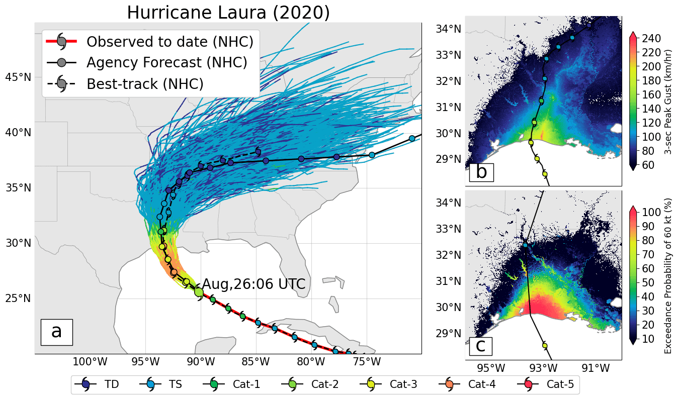
Figure 1: Hurricane Laura (2020). Left: the input NHC forecast (black) with 1,000 LiveCyc realisations (coloured), widening with lead time as uncertainty grows. Top right: the peak gust footprint for one realisation. Bottom right: the probability of exceeding 60 kt across all 1,000 runs. Source: Loridan et al. (2026), BAMS, CC BY.
How well it holds up
The paper reconstructs what LiveCyc would have produced ahead of 16 US hurricane landfalls between 2017 and 2024, using the real forecasts issued at the time. Milton, Helene, Ian, Ida and Laura are among them. The results are checked against 1,840 surface wind observations recorded during those storms.
Two days out, the modelled distributions line up closely with what was recorded. 87% of observations fell inside the modelled 90% confidence interval, and the median forecast carried a bias of half a knot, an RMSE of 13.4 kt and a CRPS of 7.5 kt.
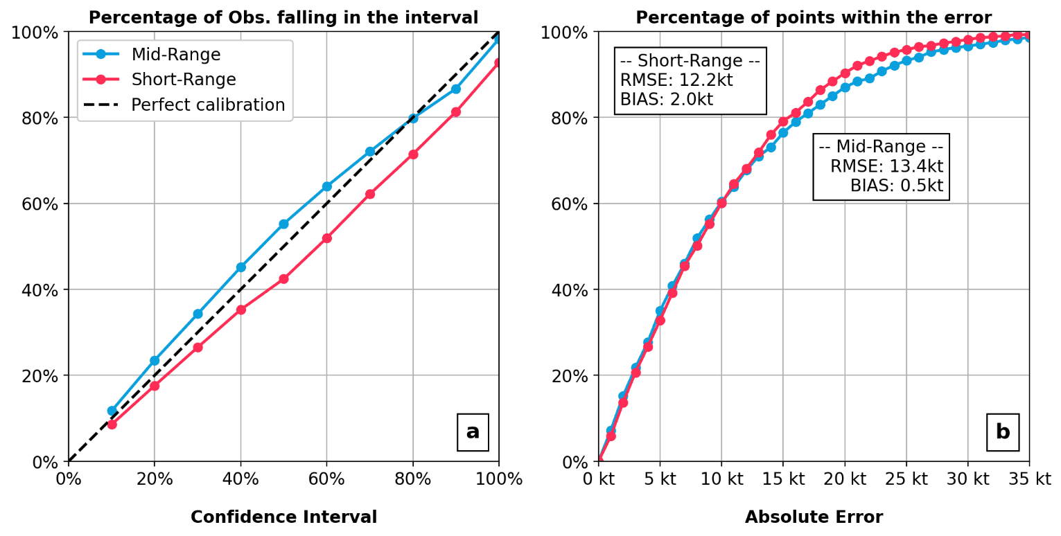
Figure 2: Summary evaluation across the 16-event back-test: model calibration (left) and error against observations (right), for the two-day and one-day forecast windows. Source: Loridan et al. (2026), BAMS, CC BY.
From a forecast to a decision
A probability on its own does not tell you when to act. The paper closes that gap using the US Navy’s Tropical Cyclone Conditions of Readiness (TC-COR) framework, the same structure the Navy uses to stage protective action ahead of a storm.
It shows how to set an objective trigger: at what probability of damaging wind does acting become worth more than not acting, given the cost of the action and the cost of the damage it prevents.
Worked through two illustrative naval-base scenarios, the same forecast supports two different calls. A low-cost action like evacuating non-essential personnel is worth triggering at an 8% probability of exceeding 60 kt. A far more expensive one like confirming a fleet sortie is not worth triggering until that probability reaches 33%. The forecast is the same; the trigger is tuned to what the decision costs. And because the trigger is objective, these protective actions can themselves be financed by a parametric insurance payout released on the same forecast threshold.
The collaboration behind it
The paper is co-authored with scientists from the US Naval Research Laboratory and NOAA, and built around the US Navy’s TC-COR decision framework. It is the fifth peer-reviewed paper in the Reask tropical cyclone model series, and a companion to the Metryc study, which applies the same wind field model to post-event reconstruction.
Explore the back-test
Every back-test forecast map, and the full threshold-calibration analysis, is available in the interactive decision tool below: