The newsletter for climate-aware risk professionals.
The climate producing today's storms is not the climate that produced the historical record. Join 400+ risk professionals receiving the latest insights from Reask direct to their inbox.

Insights
Neighbourhood-scale wind data powers new live hurricane risk transfer contracts
ForecastEx’s Live Hurricane contracts settle on Reask’s Metryc wind reconstructions. Reask’s LiveCyc probabilities give a fair-value reference for pricing contracts before a storm resolves. At scale, these contracts could let capital providers enter and exit live catastrophe exposure in real time, in a liquid and efficient market. Tropical Storm Isaias, forecast to reach the Gulf Coast as a hurricane on Friday, may be the first strong storm these contracts trade through.

Thomas Loridan
Chief Science Officer, Reask

Patrick Brown
Head of Climate Analytics, Interactive Brokers

Jamie Rodney
CEO, Reask

David Schmid
Global Head of Data Products, Reask

Balaji Mani
Head of Extreme Events, Reask

Nicolas Bruneau
Co-Founder, Reask
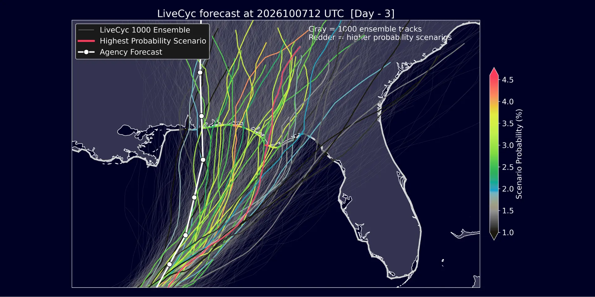
Tropical Storm Isaias formed in the Gulf this morning and is forecast to become a hurricane on Thursday, with landfall on the northern Gulf Coast expected on Friday.
Live Hurricane analytics for Isaias are available on ForecastEx. These Live Hurricane contracts are a new class of exchange-traded contract tied to wind gusts at specific coastal locations.
Reask supplies two sets of data behind them. Metryc wind reconstructions determine how each contract settles. LiveCyc probabilities are published on the ForecastEx platform as a reference for fair value while a storm is active. This article explains how both work, what a re-run of Hurricane Laura shows about prices before landfall, and what the contracts mean for reinsurers, cedents and ILS funds.
Live storm risk transfer moves onto an exchange
Interactive Brokers' ForecastEx has listed a new class of tradeable event contracts, referred to as live hurricane contracts, tied to wind gusts produced by individual named storms at specific coastal locations (Brown, 2026). Reask's Metryc product (Mani et al. 2026) serves as the settlement basis for these contracts, and Reask's LiveCyc forecasts (Loridan et al. 2026) are published on the ForecastEx platform as the shared source of fair market value.
Risk transfer instruments tied to an active, unresolved storm are not new. Industry Loss Warranties (ILWs) and short-dated retrocession have long been used to transfer concentrated hurricane exposure on short notice, as a storm approaches landfall. These instruments generally carry a high basis risk and are typically negotiated bilaterally, through brokers, with pricing determined by direct negotiation rather than by reference to an observable market price. As a result transaction and search costs are relatively high, and no independent price signal exists outside of the negotiated transactions themselves. The new live hurricane contracts on ForecastEx propose to transfer the same category of risk, structured as exchange-traded, continuously priced instruments rather than bilateral “off-line” agreements.
Looking back historically, the Chicago Mercantile Exchange (CME) has offered tradeable hurricane contracts based on a storm-wide index. Whilst the CME platform did see modest exchange-traded volume, its scalability was likely limited by the high basis risk associated with a storm wide metric and the reduced storm activity observed from 2008 to 2015 when no major hurricane made landfall in the US (a.k.a. “the hurricane drought”). Catastrophe bonds, which have become a stable source of alternative reinsurance capital, do offer liquidity during a live event; however, high volatility and the lack of an objective pricing metric during such events often limits market participants from trading them reliably in real time.
The new contract structure
Live hurricane contracts are defined over a fixed set of 163 coastal locations spanning the US Gulf and Atlantic coasts, the Caribbean, Mexico, Central America, and northern South America (see Fig 1 in Brown, 2026). Each location corresponds to a settlement footprint with a 10 km radius, evaluated at 1 km spatial resolution. This granular resolution is designed to relate closely to the damaging wind speeds and likely impacts at a location, which creates a mechanism to reduce the basis risk of the previously available structures noted above.
For a given named storm, contracts list once forecast probabilities of 70 mph or greater gusts at a location exceed a defined threshold (approximately 5%), and remain open through a ladder of gust thresholds from 70 mph to 200 mph in 10 mph increments. A separate contract type resolves which of the covered locations records the highest gust produced by a given storm. Contracts trade continuously over the life of the storm and settle within days of the storm's dissipation.
Settlement methodology
Settlement of a wind-gust contract requires a defined, verifiable measurement of peak gust at a specified location. Three candidate approaches were available to ForecastEx: direct anemometer observation, official post-event reporting, and physics-based modelled reconstruction.
Direct observation is limited by the documented tendency of surface instruments to fail under the conditions a contract is intended to measure: loss of power, loss of communication, or physical destruction of the instrument are common during major hurricanes, and coastal and airport weather stations frequently go offline during the period of peak winds. Official post-event reports, such as National Hurricane Center (NHC) Tropical Cyclone Reports, address the reliability problem but not the timeliness or standardisation requirements of a tradeable contract as these are typically published months after an event and mostly narrative in form rather than structured, location-indexed data.
Reask's Metryc product addresses both constraints by reconstructing peak three-second gust wind speed at 1 km resolution for every location affected by a storm, derived from the storm's observed track and intensity combined with a physical model of wind-field interaction with the underlying terrain (Mani et al., 2026). This produces a location-indexed, standardised measurement independent of whether a physical instrument was present or functioning at that location, and is the same reconstruction methodology already used as the basis for payout determination in parametric insurance products. Peak three-second gust, rather than one-minute sustained wind, is used because it correlates more directly with structural damage and aligns with the wind speed metrics used in engineering design codes.
Fair market price
Settlement determines the outcome of a contract after a storm has passed. A separate question is how a contract should be priced while the outcome remains uncertain. In other words, what constitutes a fair price at a given point in the life of a storm?
Reask's LiveCyc product provides a probabilistic forecast of the likelihood that a given wind-gust threshold will be exceeded at a given location, updated on a six-hour cycle as new forecast information becomes available (Loridan et al., 2026). This probability can be treated as a fundamental reference value. In the absence of other considerations, a contract's price should track the underlying probability of the event it resolves.
In practice, observed market prices are expected to diverge from this fundamental value by a premium reflecting factors outside the probability estimate itself, such as compensation for bearing risk over the remaining duration of the contract, the cost of capital tied up in a position, and the bid-ask spread required to exit a position before settlement. A market price can accordingly be decomposed as the LiveCyc probability plus this premium, with the premium expected to narrow as a storm approaches landfall and forecast uncertainty declines, and to widen during periods of elevated uncertainty, such as when a storm is rapidly intensifying or its track remains highly uncertain. This decomposition gives market participants a basis for evaluating whether an observed price reflects a premium or discount attributable to factors other than the underlying meteorological probability, including information potentially not yet incorporated into the forecast itself, as noted below.
Illustrative example: Tropical Storm Edouard
ForecastEx's live analytics interface (Weather Climate Human Systems, 2026) tracks both the exchange price (the market's Yes-side midpoint, at each listed gust threshold) and Reask's LiveCyc forecast probability, updated on the same six-hour cycle. Figure 1 shows the timeline of LiveCyc exceedance probabilities at three wind thresholds (60, 70, and 80 mph) for Tropical Storm Edouard (2026).

Figure 1. ForecastEx live analytics, Tropical Storm Edouard (2026).
Edouard was the first named system for which live Atlantic hurricane contracts were deployed on ForecastEx and, given the low level of storm activity so far this season, was the only one before Isaias. It was a comparatively weak system: at the four Gulf Coast locations shown (Lake Charles, Port Arthur, Lafayette, and Baton Rouge), LiveCyc's forecast probability of exceeding the lowest listed thresholds remained low throughout the storm's approach and declined toward zero as the storm passed each location. This is consistent with the eventual Metryc settlement values, all well below the lowest listed threshold: 50.3 mph at Lake Charles, 55.9 mph at Port Arthur, 30.4 mph at Lafayette, and 28.0 mph at Baton Rouge.
Isaias may provide the first live exchange data for a more intense system. Until it settles, the following case study uses a re-run of Hurricane Laura (2020), targeted at a location in the same region, where forecast probability at thresholds near the eventual outcome moved substantially in the days before landfall.
Case study: Hurricane Laura at Port Arthur, TX
We illustrate the dynamics described above using a re-run of Hurricane Laura (2020) through Reask's current modelling system, evaluated at Port Arthur, TX (29.885, -93.940), a location approximately 25 km west of Laura's eventual landfall point.

Figure 2. Wind exceedance probabilities as modelled by Reask for Hurricane Laura (2020) at Port Arthur.
Figure 2 shows the exceedance probability curve, P(gust ≥ threshold), produced by LiveCyc at each of eight successive forecast initialisations between 25 August, 06Z and 27 August, 00Z, alongside an immediate post-landfall estimate (“Metryc interim”) and the final Metryc reconstruction of the gust actually produced at the location ("Metryc Historical"), shown as a white vertical dashed line. Two features are relevant to the pricing discussion above.
First, exceedance probability at low thresholds (60-80 mph) is high and comparatively stable across nearly all forecast cycles: by 25 August, 12Z, roughly 36 hours before the reconstructed outcome, the probability of exceeding 60 mph gusts at this location was already above 90%, and it remains near 100% through all subsequent cycles. The location's exposure to tropical-storm-force winds was established well in advance, and priced accordingly with little remaining uncertainty.
Second, exceedance probability at thresholds close to the eventual outcome (100-120 mph) is far less stable and moves substantially with each six-hourly update, reflecting changes in NHC track and/or intensity projections. At the 25 August, 06Z initialisation, the modelled probability of exceeding 100 mph was 10%; by 26 August, 12Z it had risen to 76%; by 27 August, 00Z it reached 82%. The final Metryc reconstruction places the actual peak gust at this location just above 100 mph, with probability collapsing sharply for thresholds above approximately 110 mph.
In the final 24 hours before landfall, these estimates stabilised noticeably: the probability of exceeding 100 mph moved from 76% to 80% to 82% across the 26 August, 12Z, 26 August, 18Z, and 27 August, 00Z initialisations, a shift of only a few percentage points, in contrast to the larger day-to-day swings observed earlier in the forecast period (for example, from 10% to 42% between the 25 August, 06Z and 12Z initialisations). This convergence is consistent with the narrowing of track and intensity uncertainty typical of the final approach to landfall, and it is over this same window that the LiveCyc forecast comes to closely resemble the eventual Metryc reconstruction.
Implications for market participants
We believe that, once trading volumes reach a scale more comparable to existing live catastrophe risk transfer markets, live hurricane contracts could offer reinsurers a genuinely new capability. One where they can enter and exit live catastrophe exposure in real time, in a liquid and efficient market. The same continuous, exchange-traded pricing could in principle extend live catastrophe risk transfer to a broader base of capital providers, giving brokers a new instrument around which to structure bespoke risk transfer products for their clients.
However that level of capacity has not yet materialised, and at current trading volumes reinsurers cannot yet lay off a material share of live exposure. The more immediate effect is therefore on price visibility. Because live cat and short-dated retro pricing has historically been determined through bilateral negotiation with no external reference point, a continuously updated, publicly observable price for wind-gust exceedance already provides a benchmark against which bilateral quotes can be evaluated.
For ILS funds, this has a specific application: positions in these instruments have typically been valued using internal models between formal reset points, such as contract renewal or loss events, without an external market price. An exchange-traded reference price for the same underlying risk at a defined set of locations and thresholds can provide a partial basis for interim valuation.
A further implication concerns forecast information content. Because contract prices update continuously in response to new information, and can in principle move faster than the six-hour update cycle of the underlying forecast, resulting prices may at times incorporate information not yet reflected in individual forecast products, including Reask's own. Over multiple seasons, this raises the possibility that these markets could serve as a supplementary indicator of storm risk, alongside existing forecast sources.
Reask's function in this arrangement is limited to the provision of two types of output: a probabilistic forecast of wind exceedance prior to and during a storm (LiveCyc), and a deterministic reconstruction of peak wind gust following a storm (Metryc). Reask does not participate in the contracts as a counterparty, does not hold a position, and has no exposure to contract outcomes. This role is structurally equivalent to that of a data or settlement provider in other exchange-traded markets: the function is to supply a consistent, independently verifiable measurement that market participants can rely on, not to express a view on the outcome being measured.
Disclosure
Reask supplies commercial wind forecast (LiveCyc) and settlement (Metryc) data to Interactive Brokers' ForecastEx platform under a commercial agreement.
Sources
Brown, P. (2026). Live hurricane wind gust prediction markets at ForecastEx. IBKR Campus.
Loridan, T., Bruneau, N., Mani, B., Sampson, C. and Knaff, J. (2026). Local-scale wind forecasting for tropical cyclone early warnings. Bulletin of the American Meteorological Society, 107(9).
Mani, B., Loridan, T., Bruneau, N., Hannah, N. and Schmid, D. (2026). Reask Metryc: a probabilistic wind gust model for tropical cyclone event response with global coverage. Journal of Catastrophe Risk and Resilience, 4(5).
Weather Climate Human Systems (2026). Hurricane prediction markets, tracks and wind contracts.